Water Erosion
Water Erosion Processes: Detachment, Transport and Sedimentation:
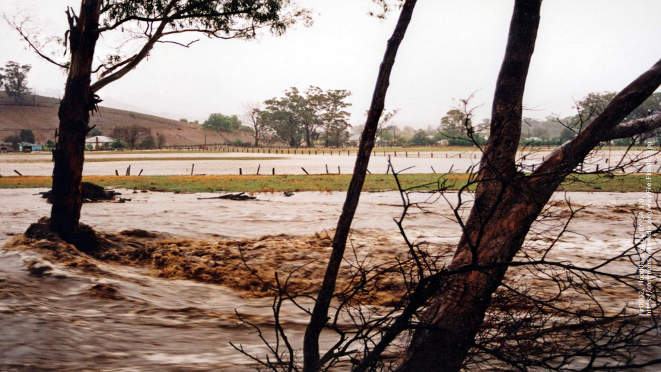
I'll explain the fundamental processes that are involved in water erosion. But firstly, we need to know when overland flow occurs. This is also called surface run-off. There are 2 types of overland flow. These are infiltration excess overland flow and saturation excess overland flow.
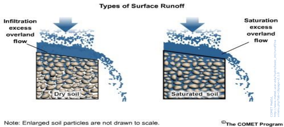
Firstly, let’s begin with infiltration excess overland flow. Now infiltration excess overland flow occurs when rainfall at the soil surface is greater than the soil’s infiltration capacity. In other words, the rainfall is greater than the ability of the land to soak up or absorb the rainfall, and thus overland flow results. Another term that you may have heard for infiltration excess overland flow is Hortonian overland flow. But we can also have saturation excess overland flow. This is where rainfall has saturated the soil so much that it raises the underground water table to the surface, then water is unable to continue to infiltrate and thus saturation excess overland flow occurs. So in summary, when the rainfall input is greater than the ability of the land to soak up the rain or when the soil profile is already saturated, then the excess water results in overland flow.
Why do we need to know all of this?
By fully understanding when overland and the resulting water erosion processes occur, we can make informed decisions about limiting the negative effects of water erosion to ensure the sustainable management of our soils. So let’s start with the 3 important processes in any water erosion event. These are:
Detachment
Transport
Deposition
All three of these terms sound quite straight forward, however, there are some complex physics that underpins them. I'll simply be talking more generally about the detachment of sediment, the transport of sediment and the deposition of sediment. Note that the ultimate goal in any soil conservation measure is to limit sediment detachment, reduce its transportation and thus decrease deposition. In other words, let’s try and keep the soil where it is meant to be.

Firstly, let’s look at detachment. Detachment is pretty much as it sounds. It means to initially get moving or to mobilize from an existing stationary location. So we are talking about the starting point for any water erosion to take place. Detachment can occur in a number of ways. These can include:
Rainsplash or raindrop impact and Flowing water, trampling by people or livestock and tillage practices. These detachment processes provide the sediment to be transported by overland flow.
Let us now look at transportation. Sediment transport by water is a complex process driven largely by gravitational forces moving sediment downslope by overland or river flows from a source area to a sink area where sediment is eventually deposited. Where, how much and how far sediment is transported, is a very tricky thing to determine. Sediment transport occurs in shallow overland flow and in stream or river channels.
However, where overland flow is generated and there is sufficient sloping land with readily available sediment, such as recently ploughed pad-docks then sediment transport is very likely to occur. This now leads us to the final of the three water erosion processes deposition. Deposition can be triggered by changes in the speed or velocity of over-land flow through reductions in surface slopes. This reduction in slope, reduces the speed of overland flow and also the ability of the flow to continue to transport its sediment load. Thus resulting in deposition. An example of this is shown here of how a grass strip can impact overland flow and promote sediment deposition.

A recent rainfall event over this ploughed field resulted in shallow over-land flow. Flows from the upslope areas move downslope from left to right due to gravity. The flow was 10-15cm deep in the downslope ploughed area shown here. The effect of the grass strip was to impede or slow down the overland flow. It reduced the transport capacity or the ability of the water to keep transporting sediment by locally decreasing the slope and thereby slowing the flow velocity or speed of the overland flow. The result is that the flow was unable to maintain the existing sediment load being transported. So sediment was deposited from the overland flow in the area as shown to the right of the grass strip.
Forms of Water Erosion:
There are many forms of water erosion. These include:
Sheet or interill erosion
Rill erosion
Gully erosion stream or river bank erosion
Mass movement
Sheet erosion occurs when thin layers of soil are removed through raindrop impact and shallow surface flow. As an erosive agent, sheet erosion is a subtle but serious process, that can remain largely unnoticed in the landscape. However, discoloration at the soil surface is a clue that sheet erosion has removed the more productive near-surface layers, exposing sub-soils nearer to the surface. So what is the problem? Well, the concern is the combined or cumulative effects of sheet erosion over time. It reduces the productiveness of the land through the loss of large quantities of soil and with it, nutrients and organic matter that plants need. It can often be seen in areas between rills.

So now let’s investigate rill erosion. Rill erosion occurs when shallow overland flow, as evident in sheet or interill erosion, begins to concentrate water as it flows downslope. Rills develop when surface water concentrates into depressions or low points in paddocks or fields, incising or cutting into the soil surface and causing it be eroded. These rills are like shallow drainage lines or small channels that can be up to 30 cm deep and about 50 cm wide. Rill erosion is most common in bare agricultural land, especially overgrazed land and in freshly tilled soil where the soil structure has been loosened by ploughing. These rills can normally be removed by ploughing.

But what about rills that cannot be removed by ploughing? Then the rill is now called a gully. In other words, the advanced form of a rill is the initial stage of gully formation. Gully formation is initiated when the depth and width of the rill is generally greater than 50 cm. Gully erosion occurs when runoff concentrates and flows strongly enough to detach and move soil particles. It is this concentration of flow we mentioned earlier that helps to form both rills and gullies. Gullying is more evident on hillsides when cleared of vegetation and where over-grazing occurs. It is also a highly visible form of soil erosion that impacts the productivity of farmland and restricts land use and can also damage roads, fences and buildings.
Gullies are generally steep-sided channels, with their depth often limited by the depth of the underlying rock, which means gullies are normally less than 2m deep. However, they can reach depths of 10–15m in much deeper soils. Gullies generally become active only during high intensity, but short duration, rainfall events when overland flood water is concentrated into the gullies. Despite being active during individual storm events for time intervals of only minutes to hours, gullies can transport large quantities of sediment which is deposited downstream.

Another form of water erosion is stream or river bank erosion. This occurs when water flowing within semi-permanent or permanent rivers or streams, undercuts the banks by concentrating water along the channel margins. Flow naturally moves between the banks of a river or stream. However, higher or more extended periods of water flow can undercut an area of the bank, resulting in bank collapse. But the presence of tree roots can help to minimize the rate and amount of bank erosion.

Finally, there is mass movement, which is sometimes referred to as mass wasting. This represents the largest form of water-based erosion and occurs in several forms. Have you ever gone past a grass-covered hill and seen some rather unusual grass-covered ripples?
Well, what you are seeing is soil creep, one of the slowest forms of mass movement. Soil creep can take many years before it is visible in the landscape with tilting posts, damaged retaining walls and sloping trees providing clues of active soil creep. At the other extreme, landslides, mud flows and debris flows are examples of some very rapid forms of mass movement events. This mobilization of soil and water can all occur unexpectedly in a matter of seconds, but the impact can devastate communities in their path and can instantly reshape the local landscape.

In conclusion, by recognizing and understanding these forms of water erosion, we can then try to minimize their impacts, which can help us to maintain sustainability.


Comments
Post a Comment